
The USGS Logged It as an Earthquake. It Was 1,200 Metres of Mountain Falling.
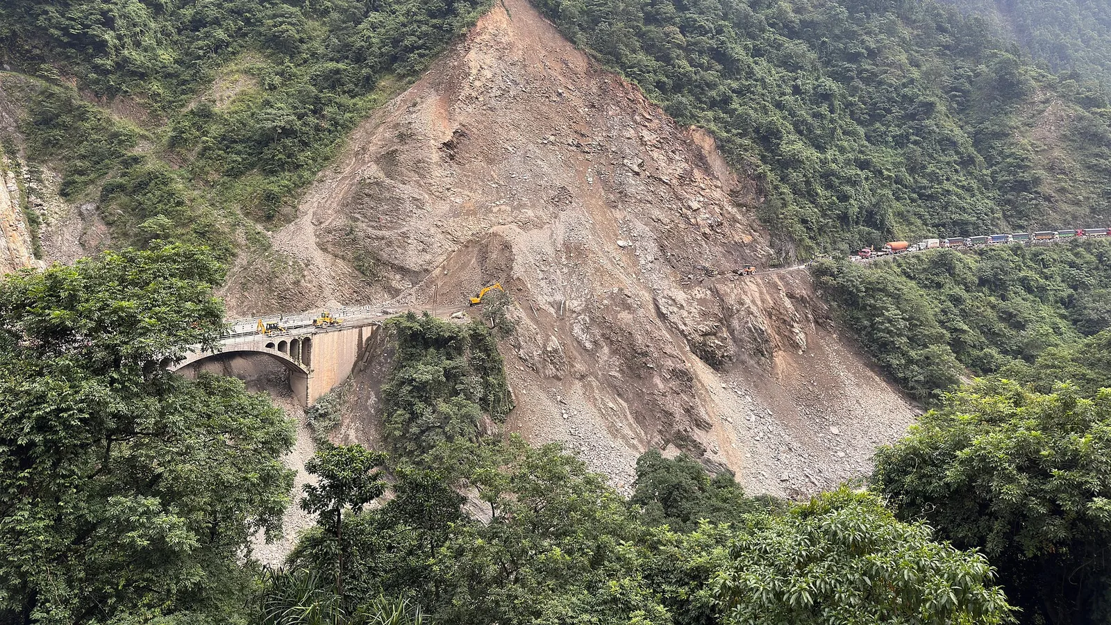
Scientists now say the Rasuwa flood began with an ice-and-rock avalanche that fell 1,200 m, dammed a river inside Tibet, and burst hours later — and that the dam did not exist the previous morning.

On the morning of 26 August, seismometers picked up a signal on the Nepal–Tibet border and the US Geological Survey logged it as a magnitude 4.4 earthquake. It was later reclassified as a magnitude 5.2 landslide. ICIMOD reports the water began rising at around 9:00 am local time, and that unusual seismic signals were recorded at stations in Jilong, 12 km away, and Zhangmu.
That reclassification is the whole story. What the instruments recorded was not the earth's crust moving. It was roughly 1,200 vertical metres of ice and rock arriving in a valley floor hard enough to register as a moderate earthquake.
What we know
- An ice-and-rock avalanche came off a glacierised slope high above the Lhende Khola, inside Tibet.
- It fell roughly 1,200 m (3,900 ft) before hitting the valley below.
- The debris dammed the river, forming a temporary lake that then burst.
- The site is about 19 km (12 miles) north-east of the Rasuwagadhi–Gyirong border crossing.
- Downstream, the Galchchi gauge rose nine metres in thirty minutes; Malekhu rose seven metres over a similar period.
How it happened, step by step
This was not a glacial lake that quietly filled and overtopped, which is the classic GLOF picture. It was faster and blunter than that.
A mass of ice and rock detaches from a glacierised face high above the Lhende Khola, on the Tibetan side of the border.
It drops roughly the height of one and a half Burj Khalifas before reaching the valley. The impact registers on seismometers as a magnitude 5.2 event.
Debris blocks the Lhende Khola. Water backs up behind it, forming a temporary lake nobody is monitoring, in terrain nobody is standing in.
The blockage fails and releases everything at once — the stored water plus the debris holding it back.
The wave travels down the Bhote Koshi into Rasuwa, taking the Rasuwagadhi border post, bridges, hydropower infrastructure and the only overland road linking Kathmandu to Tibet.
What 1,200 metres of falling mountain looks like
The number is hard to picture, so here it is against things that are easier to hold in your head.
Why nobody was warned
A glacial lake that fills over weeks can, in principle, be watched. Nepal has installed early-warning systems on several of them.
This was not that. The dam that failed here did not exist the previous morning. It was created by the avalanche and destroyed within hours, in a valley across an international border, at an altitude where nobody lives. There was no lake on any inventory to monitor, and the interval between the blockage forming and bursting was too short for a warning to travel even if someone had been watching.
That is the uncomfortable finding, and it is why this event is being studied so closely: the existing early-warning model assumes you know which lake to watch.
What it means if you are trekking this autumn
Two things, and they pull in opposite directions, so we will give you both.
The reassuring part. This was a border-zone event in one river system. The Annapurna and Everest regions are in different catchments entirely and were untouched. Autumn trekking on those trails is going ahead normally.
The honest part. Events of this type are becoming more frequent across the Himalaya as slopes that were frozen for centuries thaw. That is not a reason to stay away — it is a reason to trek with people who read the conditions rather than assume them, and to carry insurance that covers helicopter evacuation to 4,500 m rather than the 3,000 m most policies quietly cap at.
Open right now · Annapurna & Khumbu


Planning a trek this autumn? We keep a live region-by-region status page — which trails are open, which access roads are cut — updated through the season by our team in Pokhara: Nepal trekking conditions right now.
Sources. Satellite analysis and the ice-rock avalanche interpretation: the International Centre for Integrated Mountain Development (ICIMOD), working with Nepal's Department of Hydrology and Meteorology and Chinese counterparts, using Sentinel imagery. Seismic reclassification from magnitude 4.4 earthquake to magnitude 5.2 landslide: the United States Geological Survey. Casualty and infrastructure figures are provisional and have risen daily since 26 August.
Trekking Annapurna or Everest this autumn?
Both are open and running normally. These are the two we are putting people on for October and November, at the price a pair pays:
- Annapurna Base Camp — 7 days · from US$730 per person
- Everest Base Camp — 14 days · from US$1,650 per person
计划徒步?
我们负责许可证、后勤与向导
NMA 认证的本地向导,价格透明,自 1998 年以来 5,000+ 次徒步。告诉我们你的日期,其余的交给我们。


更多「Climate & Environment」

Climate & Environment
Nepal Lost a Tenth of Its Power Grid in Thirty Minutes
431 megawatts gone, six plants down the same river, and another 470 MW damaged before it was even finished. The Rasuwa flood was a national infrastructure event, not just a mountain one.
Climate & Environment
Nepal Has Mapped 2,070 Glacial Lakes. The One That Burst Was Not On the List.
A new ICIMOD and UNDP inventory counts 3,624 glacial lakes and flags 47 as dangerous — 42 of them in the Koshi basin. The lake that killed at least 165 people in August was not among them, because it did not exist the day before.
Climate & Environment
Nepal's Monsoon Is Turning Erratic and Extreme: the Climate Science Behind the Floods (2026)
A warmer sky holds more water, and Nepal's rains now arrive in shorter, fiercer bursts — driving worse landslides and floods.